“Many Pools” Canyon hike in Zion

Continuing our desire to hike away from the spring break crowds in Zion, we returned to the upper east side of Zion and did a short hike in “Many Pools” Canyon. I’m sure that is not its official official name—in fact, it probably has no official name. Karen and I have enjoyed this hike several times.

Many Pools Canyon

It’s an open canyon with lots of slick rock peppered with pools of water (at least in spring). The kids had fun finding tadpoles and frogs.

Pools in the slick rock

Links:
St. George 2015 photo gallery

Separation Canyon and Checkerboard Mesa Canyon hike

These two canyons are on the upper east side of Zion, near Checkerboard Mesa. Neither appear on national park maps or trail descriptions. If fact, there are no trails, save an occasional use-trail. Route finding, which is relatively easy, is mandatory. Karen and I have been in Separation Canyon a couple of times.

Mark wanted to take Chase hiking in someplace less crowded than the main canyon, so with a little research on the web and perusing the relevant topographic maps, I put together a route that I thought would be interesting. We would head up (south) Separation Canyon. After exiting the head of the canyon, we would circle around to the east to the next canyon (Checkerboard Canyon) and then head down (north) it back to the road and the car. It would be over 5 miles.

The bottom of Separation Canyon has a dryfall that would be impassable for us, so we bypassed it by walking in from the east a ways. I remember struggling with the route here the first time, but now I’ve got it figured out. This is an open canyon and we stayed to the left (east) side, even detouring into the large, juniper and pine filled bowl. I began to see signs of bighorn sheep and hoped we’d spot some. We circumnavigated the bowl and then reached the top of the canyon. This part was pretty sandy.

Hiking into the bowl in Separation Canyon

After topping out, we could see a vast drainage down to the Parunaweep Canyon. We cross-countried to the east, across a couple of low ridges, until we could access the head of Checkerboard Canyon across a slab of slanty slickrock. We came across a spot where bighorns had loitered for a while recently—lots of droppings and still damp urine spots. But we hadn’t seen any sheep.

Slickrock abounds

The head of Checkerboard Canyon was like a big sand dune that dropped steeply into the canyon running to the north. I am definitely glad we did not choose to come up that canyon. When we got down to the rocky parts, the canyon closed in and became narrow. At one point we heard a rock tumble down to the canyon floor and froze, hoping it would miss us. As we scanned the side of the canyon to see if any more rocks might be falling we spotted the bighorns. We saw 3 adults and 2 kids, grazing on the brush. One of them must have dislodged the rock. That was lucky for us because we would never have spotted them otherwise. We watched them for quite a while.

Checkerboard Canyon

After getting back to highway 9 we walked along Pine Creek (roughly) to get back to the car. We covered a little less than 6 miles.

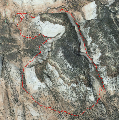
Here’s a photo of the track we followed.

Track for Separation and Checkerboard Canyons hike

Track for Separation and Checkerboard Canyons hike

Links:
St. George 2015 photo gallery

Hike to Scout’s Lookout and Emerald Pools

After a fairly laid back day we headed into Zion Canyon for a hike up to Scout’s Lookout (on the way to Angel’s Landing). Parking was a hassle. Most of the visitor center parking was out of service for renovation so after dropping the crew off at the visitor center we headed back into Springdale to park. Luckily, we were not too late in the morning so we found parking relatively close to the park entrance. Then we waited in line for a shuttle bus. It was packed—standing room only.

The trail up to Scout’s Lookout (and Angel’s Landing) seemed to be a solid line of people. It was more crowded than any other time I have been there. We got up the initial switchbacks that were getting a bit warm, through Refrigerator Canyon, and started up Walter’s Wiggles (more switchbacks) when we were stopped by a ranger. They were 3-D scanning the trail in order to make a digital 3-D model. After a 10-minute halt, during which we conversed with the ranger, we hiked on up in the midst of the stampede. We ate our lunch at Scout’s Lookout, looked over the side, and marveled at the huge number of ill-prepared hikers struggling to pass each other on the route up Angel’s Landing.

If I had a desire to go up there (I don’t), I still would not have gone. Those people were not trustable, nor prepared, and their mistake might put me in peril.

I didn’t take any photos, but here’s a shot of the canyon taken May 16, 2013 from Scout’s Lookout. All those trees that look so green were just beginning to bud this year in early April.

Canyon floor from Scout Lookout, May 16, 2013

A few years ago we stopped to talk with a ranger who had set up a spotting scope at Big Bend aimed at the cliff wall below Scout’s Lookout. He said there was a condor nest there, but we never saw one. I asked our ‘captive’ ranger about the condor population and he said unfortunately they had lost eight of them last year to lead poisoning. They still have a breeding pair that hatched a chick last year, but it didn’t survive.

We hiked back down and caught a very crowded shuttle to Zion Lodge where Mark and Cortnie were waiting. Mark wanted to take Chase up to the Emerald Pools, so while the rest stayed at the Lodge, I accompanied them to the three pools (lower, middle, and upper). I have never been to the upper pool. The waterfall was dry and the pool area was as packed as a Disneyland ride.

Upper Emerald Pool was packed

We stayed a bit for Chase to play in the pool’s sand, and then headed back.

Mark and Chase

The shuttles back to the visitor center were so crowded. I think we had to let three go by because there was no space, and the one we got on must have been a special because it arrived empty.

Links:
St. George 2015 photo gallery