Before settling in at our rental cabin in the Teton Valley for a week we wanted to spend some time in Yellowstone. We stayed in West Yellowstone for a couple of nights at the One Horse Motel (older, small, clean, and completely met our needs) before heading to Driggs, ID. I first tried to get a reservation at the Alpine Motel (that has highly rated reviews) but they were booked up and referred me to the One Horse.*

View from Biscuit Basin overlook
We got in a couple of nice hikes starting along the Firehole River. While Yellowstone is best known for its thermal features, this trip we focused on other things, like waterfalls. For our first afternoon we started at the Biscuit Basin parking area and hiked about 1.5 miles to Mystic Falls, then continued on in a loop climbing to Biscuit Basin overlook. There were good views from here (we even watched Old Faithful erupt way off in the distance).

Fairy Falls
The next day we returned to the same general area and parked at a trailhead at the end of Fountain Flats Drive. We headed off along an old freight road anticipating about a 5 mile round-trip according to the reference I was using. The route is flat across an open meadow. Perhaps there used to be stands of trees, but the huge 1988 fires took care of that. We passed ponds, some thermal springs, and a very wet meadow area where we walked on elevated split logs. Eventually we got to Fairy Falls, after 5 miles! So this was a 10 mile round-trip, not 5. Fairy Falls is impressive, but the sun was in absolutely the wrong position for photos. After our hike we drove to the Yellowstone Inn for coffee and to admire the old inn’s architecture.

Bison calf
On our drive back to West Yellowstone we got hung up in a traffic jam caused by a small herd of bison walking down the centerline, in absolutely no hurry and paying no attention to the cars. I was reminded again how instantly stupid some people become when they see Yellowstone wildlife. They will stop in the road (because the shoulders are already full of cars), get out of their car, and excitedly take photos. The resulting traffic jam can be a few miles long.
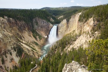
Lower Yellowstone Falls
After checking out of our motel we took the long way to Driggs stopping at Yellowstone Falls for a short hike. We were surprised when walking through a small pine grove and suddenly realizing there was a bison grazing less than 10 yards away. The falls (upper and lower) were jam-packed with people—the trail between them was pretty deserted. After our short hike we headed for Driggs by way of Jackson. As always, the Tetons are magnificent. It was a long drive and we arrived at our rental cabin after dark—something I really don’t like to do. All went well, however, because we had stayed there before and were familiar with the roads and the check-in procedure.
*Motel links for my benefit in case I want to return.
Links
—Yellowstone 2013 photo gallery
—Yellowstone 2011 photo gallery
—Yellowstone 2011 trip report


