Lately, in my geocaching adventures, I’ve been focusing on caches that have a high difficulty and/or terrain rating. (Caches are rated on two criteria. The difficulty (D) rating is supposed to indicate how difficult it is to find the cache, perhaps because of a hard puzzle that must be solved or very effective camouflage. The terrain (T) rating is supposed to indicate how difficult it is to get to the cache hiding spot. All of this is highly subjective, of course.) A major reason for wanting to find these high D/T combination caches is to completely fill out a grid of all possible D/T combos for a challenge cache.
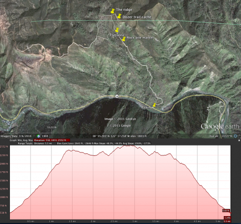
I’m currently working on A Fizzy Challenge – Whiners Edition. One hole in my grid for this challenge is the D3/T4.5 combo. While there are closer-to-home caches that have this combination, I was attracted to the hike to this cache—Dozer Trail. It’s in the Cache Creek area (past the casino and into the canyon proper.) A little research with Google Earth showed the trail (if one can call it that) to be really steep, but the views from the ridge line impressive.
After driving the 115 miles north, I was at the trailhead by 10:30 am. I followed a firebreak cut by a bulldozer a few years ago. It’s beginning to be overgrown, but there was generally a use trail to follow. It is very steep, with the steepest part in the last quarter mile before the ridge. I gained the ridge a little before noon.
There was a lot of scat on the trail, more evident on the lower parts of the trail closer to the creek. It was full of red berries that were abundant this time of year. I’m assuming it was bear scat. I didn’t see any bears, or any tracks. I was surprised a couple of times by quail exploding out of a nearby shrub (now that’s a start when you’re wondering if there are bears around), but didn’t see any animals other than a couple of deer up near the ridge line.
I quickly found the nearby cache and, since I was on the ridge, I hiked a mile along the ridge-top fire road to another cache, called Cache Overview. Along the way I spotted a rock cairn atop a high spot and went over to find the summit register for Glasscock Mountain. I wish the air quality had been better. Visibility was just a few miles so other peaks and mountain ranges were lost in the grey haze.
My descent was trickier than my ascent. First of all, I took a slightly different route and had to bushwhack just a bit. Secondly, I slipped a few times on loose rock and pebbles, but saved myself from a bruised bottom with my two hiking sticks.
My track on Google Earth reveals the average steepness was about 25%, but the last quarter mile to the ridge is over 40%.

Leave a Reply